Hiking in Andorra: Complete Guide to Trails, Transport, Costs, and Planning
Hiking’s been a huge part of my life for years. I’ve explored trails across the United States and Canada, hiked all over Europe, and even tackled a few routes in Africa. With all that, you’d think I’d have heard plenty about Andorra, but honestly, I hadn’t. I barely knew anything about it before going, and that’s exactly why it surprised me as much as it did.
For such a small country, the landscapes change fast. One minute you’re walking through quiet forest paths, and the next you’re standing above alpine lakes or climbing ridgelines with huge Pyrenees views. The trails are incredibly well-marked, and getting around is easy even without a car. If you’re already traveling in Spain or France during hiking season, adding a few days in Andorra is way easier than most people realize.
In this guide, I’ll walk you through the hiking in Andorra I did myself, the trails I researched for next time, and the practical tips I wish I’d known earlier. If you’re into hiking and want something accessible but genuinely impressive, Andorra should be on your list.

Quick Facts for Planning Your Andorra Hiking Trip
Best Time to Hike in Andorra
The main hiking season runs from June to October, when trails are clear and lakes are accessible. Higher elevations can still hold snow into early July, so check conditions if you plan summit routes like Coma Pedrosa or Casamanya.

Where to Stay for Easy Trail Access
Base yourself in Andorra la Vella or La Massana, where buses connect to most trailheads. If you want quieter mornings and faster access to the mountains, Ordino is the best compact village base.
How to Get There
There is no airport or train station in Andorra. Travelers typically arrive by bus from Barcelona or Toulouse. Travel time is usually between two and a half hours and three and a half hours depending on the route and traffic.
In my case, I came from Barcelona, and then continued toward Toulouse. If you are considering adding it to your route, my guide on whether Toulouse is worth visiting lays out exactly what to expect.
How I Structured My Trip
I hiked for several days using public transport, basing myself in La Massana. Most trailheads were reachable by bus, although some required short approach walks.
What It Cost Me
My full multi-day hiking trip cost about €230, including accommodation, buses, groceries, and a few eating-out moments. I kept costs low by staying in simple lodging, relying on buses, and choosing hikes that didn’t require guides or extra fees.

The Best Hiking Trails in Andorra (Ranked by Difficulty)
When I arrived in Andorra, I didn’t expect a country this small to pack in so many trails, landscapes, and styles of hiking. Over five days, I tried routes that ranged from relaxed valley walks to long ridge climbs that briefly crossed into Spain. All the hikes listed below are public-transport accessible, realistically doable for most travelers, and chosen because they’re the ones I would recommend first.
Each trail includes bus access, difficulty, timing, and what stood out to me on the ground.
Beginner-Friendly Hikes
La Massana to Ordino (Scenic Cultural Walk)
Distance: ~7–8 km
Elevation: Minimal
Time: 1.5 to 2.5 hours
Starting Point: La Massana
Bus: L5 or L6 to La Massana
Trail Map: Wikiloc – “La Massana to Ordino”
This is the most approachable route on the list and a great warm-up day if you’re just arriving. The trail winds through quiet residential areas, forest paths, and eventually into Ordino, one of the most picturesque villages in the country. You get mountain views without any intense climbing and a good feel for Andorra’s traditional architecture.

Who it’s for: Beginners, anyone easing into altitude, or travelers who want a half-day at a relaxed pace.
My experience: This was my “reset day” between bigger hikes. It delivered exactly what I needed without feeling like a throwaway walk.
Warning: Some sections are narrow near the roadside; stay alert.
Rec del Solà (Easy View Walk Near the Capital)
Distance: 4–5 km
Elevation: Light
Time: 1 to 1.5 hours
Starting Point: Andorra la Vella
Bus: Any line running into the capital
A simple ridge-line balcony walk overlooking Andorra la Vella. If you want views without any heavy climbing, this is the easiest scenic option. It runs parallel to the city yet feels surprisingly peaceful.
Who it’s for: Casual walkers, families, and anyone wanting a quick route with views.
My experience: I did this on a slower morning. It was perfect when my legs needed a break from the steeper terrain.
Warning: Afternoons can be hot because the path is exposed.
Intermediate Routes
La Massana to Encamp via El Forn
Distance: ~12–15 km
Elevation: Moderate +
Time: 4–6 hours depending on pace
Starting Point: La Massana
Bus: L5 or L6 to La Massana, return from Encamp
One of the most varied hikes I did in Andorra. Forest sections, open ridgelines, wide mountain views, and a descent into Encamp that feels like entering a completely different valley. This is a proper “full-day adventure” without being technical.
Who it’s for: Travelers who want a rewarding challenge but not a summit day.
My experience: This was my longest hike in Andorra and had the most consistent scenery changes. I finished tired but happy.
Warning: Bus schedules matter. Plan return timing from Encamp.
Cell Tower Ridge and the Spain Border Traverse
Distance: ~10–12 km
Elevation: Steep climb at start, rolling ridge after
Time: 4–5 hours
Starting Point: Above La Massana
Bus: L5 or L6 to La Massana, walk to trailhead
Trail Map: Trailforks – “Cami Pic de Carroi”

This began as a simple climb to the prominent cell tower above La Massana, then turned into one of the most surprising ridgeline hikes of my trip. Sweeping valley views appear at every switchback, and once you hit the top, the ridge continues all the way to the Spanish border.
Who it’s for: Confident hikers who like ridge walking and big viewpoints.
My experience: This was easily one of the most memorable hikes of the week. The Spain crossing moment is surreal when it happens.
Warning: Avoid in fog or high wind. Exposure increases on the ridge.
Challenging Hike
Coma Pedrosa (Highest Peak in Andorra)
Distance: 13–14 km
Elevation: ~1,300 m gain
Time: 6–8 hours
Starting Point: Arinsal
Bus: L5 to Arinsal, trail begins near the main car park
Trail Map: Komoot – “Coma Pedrosa”
This is Andorra’s highest summit at 2,942 m and the most demanding route I attempted. The lower forest path is gentle, but once you reach the alpine basin, the climb steepens into rocky terrain and, depending on the season, patches of snow. The views from the upper ridge are worth every step.
Who it’s for: Fit hikers with mountain experience looking for a signature peak.
My experience: I reached the high ridge but turned back just before the final summit because conditions were deteriorating. Even without the summit, the route was spectacular.
Warning: Snow lingers into early summer; weather shifts quickly at altitude.
Optional Add-On: La Massana Scenic Loop
Distance: 3–4 km
Elevation: Light
Time: 45–60 minutes
Starting Point: La Massana
A small scenic route around the village that pairs well with a café stop or an easy morning walk. Not a major hike, but a pleasant add-on if you’re staying in town.
Where to Base Yourself for Hiking in Andorra
Where you stay affects how easily you can reach trailheads, especially if you are relying on public transport. Andorra is small, but the valleys each offer a different rhythm and level of convenience for hikers. The three places most travelers choose are Andorra la Vella, La Massana, and Ordino and if you want to see how Andorra fits into my wider travels, my Destinations page includes an interactive map of everywhere I have been.
Andorra la Vella
The capital is the most central and practical base. You have supermarkets, restaurants, and frequent connections to other towns. It is not the most scenic area, and you will spend a little more time getting into the mountains, but it works well if you prefer urban convenience and easy access to services.

La Massana
This is the most balanced option for hikers. It has enough shops and places to eat, but it still feels close to the mountains. Many well known routes begin in or near this valley, and staying here keeps your daily logistics simple. I based myself in La Massana and found it ideal for quick starts, straightforward returns, and long hiking days that did not require extra planning.
Ordino
Ordino is quieter and more traditional, with beautiful surroundings and a slower pace. It is a good choice if you prefer scenic mornings, village atmosphere, and access to some of the most impressive valley trails. It does not have the same level of convenience as La Massana, but it offers a more peaceful base for hikers who value setting over amenities.

Which place fits which traveler
• La Massana suits hikers who want the easiest access to classic routes
• Ordino suits travelers who value quiet and scenery above everything else
• Andorra la Vella suits visitors who prefer a city base with full services
During my trip, staying in La Massana worked perfectly. It kept logistics simple and let me focus on the actual hiking rather than moving between valleys.
Getting Around: How Andorra’s Bus System Works for Hikers
Andorra is one of the easiest mountain destinations to explore without a car. The national bus network connects every major valley, and many trailheads sit directly on or very close to these routes. Once you understand how the system works, reaching hikes becomes straightforward.
Bus lines that reach popular trail areas
Several valleys have reliable routes that make day hikes accessible. Buses from Andorra la Vella run frequently through La Massana and Ordino, with stops near many starting points. Routes through Encamp and Canillo are especially useful for lake hikes and mid elevation trails. Some routes require a short approach walk, but most trailheads are close enough that a car is not necessary. For full route maps and current schedules, the official Andorra Mobility Guide provides the most accurate information.

Vall d’Incles summer access rules
Vall d’Incles has seasonal road restrictions. In summer, the main road closes to private vehicles during peak hours, and a shuttle runs through the valley instead. The shuttle is inexpensive and runs regularly, and it is the easiest way to reach several lake hikes in the area. If you are visiting in the main hiking season, expect this closure and plan your timing accordingly.
How often buses run
Most buses run every fifteen to thirty minutes during the day, depending on the line and destination. Services are reliable, and the network makes it possible to explore multiple valleys in a single trip. The only limitation is the evening schedule. Last buses return earlier than many visitors expect, especially outside peak season.
What surprised me during my trip
The buses were more dependable than I assumed, and many stops were closer to trailheads than they appear on the map. The only challenge was timing long hikes so I did not miss the last return. Planning your day around the final bus is essential, especially for routes with big elevation gain or slow descents.
Overall, the bus network makes Andorra one of the most accessible mountain regions in Europe for hikers without a car. With a bit of planning, it works seamlessly for long days on the trail.

Practical Hiking Tips for Andorra
Hiking in Andorra is straightforward once you understand the terrain, weather patterns, and what the trails are actually like. These are the practical details that mattered most during my trip.
Weather and seasonal conditions
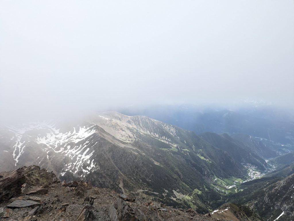
Weather in the Pyrenees can shift quickly, especially at higher elevation. On one of my hikes, thick fog rolled in mid route and visibility dropped to almost nothing. Even with well marked trails, it becomes easy to drift off the main path when conditions change. Clear mornings can turn cloudy by midday, and wind increases noticeably on exposed ridges, so planning around earlier starts is generally safer.

GPX, maps, and offline navigation
Offline maps are essential in Andorra. Even though the signage is excellent, fog, cloud, or dense forest sections can make it harder to follow the trail. I did not use GPX files, but offline maps were enough and worked well. Many apps offer free trials, and downloading the full area before leaving your accommodation is the simplest way to avoid mistakes. Without offline maps, we would have had a harder time correcting our route when visibility dropped.
Water, supplies, and shops
Carrying enough water is more important than it looks. On the Coma Pedrosa route, we ran out of water near the top and had to ration on the way down. Some valleys have streams, but they are not always reliable and many higher elevation routes have long dry stretches. Supermarkets in La Massana and Andorra la Vella make it easy to pack food, but once you start hiking there are no facilities or huts selling supplies on standard day routes.
Preparedness and footwear
Trail surfaces in Andorra are rocky, steep, and uneven, even on moderate hikes. Good footwear makes a significant difference on both ascents and descents. I do not use trekking poles, but if you already have them, they would be useful on the longer, more technical routes. A light layer is essential because the wind on ridgelines can feel dramatically colder than conditions in the valley.
Sun exposure and altitude
Many trails are exposed for long sections, with very little shade. Sun protection is important even on cooler days. While the elevations are moderate compared to other mountain regions, you will notice the effort above two thousand meters, especially on long climbs. Keeping a steady pace helps more than you expect.
Starting early
Early starts make planning easier. Morning weather is more stable, visibility is clearer, temperatures are better for climbing, and you have a full margin before the final buses return. If you are relying on public transport, the morning bus effectively determines your schedule, so it is worth building your hike around that timing.

What I Spent on My 5-Day Andorra Hiking Trip
I tracked every euro on this trip, and the total came to €229,54 for five full days. Andorra looks expensive from the outside, but when you structure your days around hiking and buses, the costs stay very manageable.
Here is the exact breakdown:
Accommodation €89,04
Public Transportation €64,70
Eating Out €33,40
Groceries €32,41
Miscellaneous €9,99
Total €229,54
Most expenses went toward two things: buses to reach trailheads, and simple accommodation in La Massana. Hiking itself costs nothing, and the best routes do not require guides, permits, or paid facilities.
This ended up being one of the most affordable mountain trips I’ve taken in Europe.

FAQs About Hiking in Andorra
When is the best time to hike in Andorra?
June to October is the main hiking season. Trails are clear, lakes are accessible, and most routes are snow free. Higher summits like Coma Pedrosa or Casamanya can still hold snow into early July, so check conditions before attempting high elevation routes.
Are buses reliable for reaching trailheads?
Yes. Andorra’s bus network is dependable and reaches many major valleys and starting points. Services run frequently during the day, but the last departures are early in the evening, so timing your descent matters. Some valleys, like Vall d’Incles, use shuttle buses in summer due to road closures.
Do I need special gear for hiking in Andorra?
Standard mountain hiking gear is enough. Sturdy footwear, layers, sun protection, and offline maps will cover most situations. For higher elevation routes, pack extra warmth and check for remaining snow. No technical equipment is needed for the classic day hikes.
Can beginners hike in Andorra?
Yes. Several routes are beginner friendly, especially around La Massana, Ordino, and the gentler valley paths. Trails with major elevation gain or rocky sections are better suited to intermediate hikers, but there are accessible options for all levels.
Are the trails well marked?
Very. Andorra’s trail network is one of the best marked in the Pyrenees. Yellow, red-white, and blue markers guide nearly every junction, and signposts clearly list distances and estimated times. Even without a car, navigation is straightforward.
Is Coma Pedrosa safe for first timers?
The full summit route is strenuous and steep, better suited to experienced hikers with good fitness. However, partial routes to the refugio or viewpoint areas are manageable for strong beginners. Weather and wind can change fast at altitude, so check forecasts carefully.
Are the alpine lakes accessible without a car?
Yes. Many lake routes start near bus stops or require only a short approach walk. Lakes in the La Massana, Ordino, and Encamp areas are especially accessible. Using buses makes lake hikes easy, even for travelers without a vehicle.
Final Thoughts
Andorra is a small country, but its hiking feels anything but small. The trails climb quickly into real mountain terrain, the valleys are easy to reach without a car, and the views shift constantly between forests, ridgelines, and alpine lakes. What stood out most during my trip was how accessible everything felt. With a simple base in La Massana, offline maps, and an early start each day, I could reach routes that would normally require a car in other mountain regions.
If you are already traveling in Spain or France, adding a few days in Andorra is much easier than most people realize. The landscapes are impressive, the hiking is varied, and the entire experience is straightforward to plan. Whether you want beginner friendly valley paths or long, high elevation days like Coma Pedrosa, the country delivers far more than its size suggests.
If you enjoy hiking that feels wild but is still practical and well marked, Andorra is absolutely worth putting on your list.